
Intense Atlantic Hurricane Frequency Increase
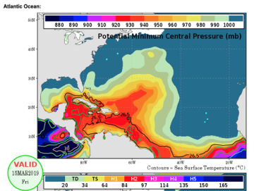
As the ocean warms, surface waters have more energy to convert to hurricane winds, which scientists say is likely increasing the intensity of the most hurricanes. This trend is strongest in the Atlantic, where rising ocean temperatures correlate closely to an increase in Atlantic tropical cyclone strength.
Read More
Climate science at a glance
- There has been a substantial increase in virtually every measure of Atlantic hurricane activity since the 1970s. These increases are linked to higher sea surface temperatures in the region where Atlantic hurricanes form and move.[1][2]
- There has been a global increase in the observed intensity of the strongest storms.[3]
- Tropical cyclones are fueled by available heat. Warming seas are increasing the potential energy available to passing storms, which increases the power ceiling or speed limit for these cyclones.[4]
- Higher sea surface temperatures are associated with more rapid hurricane intensification.[5]
Background information
Climate change is supercharging hurricanes and exacerbating the risk of major damage in three ways
There are three primary ways that human-caused climate change affects the activity of tropical cyclones. In addition to raising the potential energy available to passing storms, climate change causes sea level rise, which leads to higher storm surge — the main driver of damage for coastal regions[6] — and increases extreme precipitation.
Atlantic hurricane intensity trends and climate change
- The Fourth US National Climate Assessment (2018) states, “Increases in greenhouse gases and decreases in air pollution have contributed to increases in Atlantic hurricane activity [frequency and intensity] since 1970.”[7]
- The Third US National Climate Assessment (2014) reports that "the intensity, frequency, and duration of North Atlantic hurricanes, as well as the frequency of the strongest hurricanes, have all increased since the early 1980s."[8]
- During the 2010s, increases in sea surface temperature intensified Atlantic hurricanes at the rate anticipated in a 2008 study.[2]
- Studies have found a 30-year trend showing an increase in Atlantic tropical cyclone strength alongside an increase in ocean temperatures over the Atlantic Ocean and elsewhere.[2][5]
- In North America, storms have shaved almost a day (20 hours) off their spin-up to Category 3.[5]
- Since 1923, Katrina-magnitude events have been twice as frequent in warm years compared with cold years.[9]
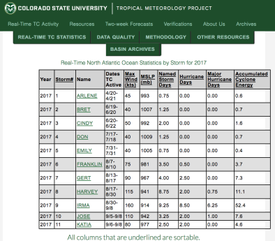
- Hurricane Irma in 2017 maintained maximum wind speeds of at least 180 mph for 37 hours, longer than any storm on Earth on record.[10] Irma’s maximum accumulated energy over 24 hours was the highest for any Atlantic hurricane on record.[11]
[T]here is strong theoretical and statistical evidence that the strongest hurricanes are getting stronger as the oceans heat up due to global warming from the emission of greenhouse gases. In fact, there is statistical evidence that the magnitude of economic damage in the US from hurricanes increases with rising ocean temperature.[12]
- James Elsner, Professor, Florida State University
Studies attribute increases in Atlantic hurricane damage to climate change
Atlantic Basin
- (Santer et al. 2006): Observed sea surface temperature (SST) increases in Atlantic and Pacific tropical cyclogenesis regions range from 0.32°C to 0.67°C over the 20th century, and this magnitude cannot be explained solely by unforced variability of the climate system. There is an 84 percent chance that external forcing explains at least 67 percent of observed SST increased in the two cyclogenesis regions for the period 1906–2005.[13]
Hurricane Harvey
- (Trenberth et al. 2018): Record high ocean heat values not only increased the fuel available to sustain and intensify Harvey, but also increased its flooding rains on land. Harvey could not have produced so much rain without human‐induced climate change.[14]
- (Wang et al. 2018): Post-1980 climate warming likely contributed to the 4-day precipitation that fell on southeast Texas during 26-25 August 2017 by approximately 20 percent, with a range of 13-37 percent.[15]
- (Risser and Wehner 2017): Climate change likely increased the chances of the observed precipitation accumulations during Hurricane Harvey in the most affected areas of Houston by a factor of at least 3.5. Precipitation accumulations in these areas were likely increased by at least 18.8 percent, with the best estimate being 37.7 percent).[16]
- (Oldenborgh et al. 2017): Global warming made Harvey’s precipitation about 15 percent (with a range of 8–19 percent) more intense, or equivalently made such an event three (1.5–5) times more likely.[17]
- (Emanuel 2017): The annual probability in Texas of a 19.7 inches (500 mm) rainfall event (which is the areally averaged hurricane rain of Hurricane Harvey’s magnitude) increased from 1 percent in the period 1981–2000 to 6 percent in 2017—a sixfold increase. This assumes a linear increase between the two research periods (1981–2000 and 2081–2100).[18]
Hurricane Sandy
- (Reed et al. 2015): The flood risk for New York City due to tropical cyclones and their storm surges has increased significantly during the last millennium due to rising sea levels. Mean flood heights increased by more than 1.2 meters from about A.D. 850 to A.D. 2005.[19]
- (Trenberth et al. 2015): High sea surface temperatures played a key role in feeding moisture into Superstorm Sandy, helping to intensify the storm and causing heavy rains. High sea surface temperatures had a discernible human component.[20]
- (Miller et al. 2013): The human-caused sea level rise of 7.9 inches (20 cm) during the 20th century caused Sandy to flood an area about 27 square miles (70 square kilometers) greater than it would have in 1880. This increased the number of people living on land lower than the storm tide by about 38,000 in New Jersey and by about 45,000 in New York City.[21]
- (Sweet et al. 2013): Sea level rise over 1950–2012 from global SLR (thermal expansion and ice melt), vertical land motion (subsidence), and ocean circulation variability has contributed to a one- to two-thirds decrease in Sandy-level event recurrences.[22]
It's the high end events that are the most destructive historically....More than half the damage that's been done in the United States by storms dating back to the middle of the 19th century has been done essentially by just eight events. So it really is the rare events, the Katrinas, the Sandys, that do the overwhelming amount of damage. Your average run-of-the-mill hurricane will do some damage and be memorable in the local place that if affects, but it doesn't really amount to a hill of beans compared to what the big storms do.
Dr. Kerry Emanuel [23]
Hurricane Katrina
(Irish et al. 2014): Flood elevations during Katrina would have been 15 to 60 percent lower around 1900 than the conditions observed in 2005. Between 1900 and 2005, sea levels in New Orleans rose 0.75 meters, 0.57 of which was due to land subsidence.[24]
(Grinsted et al. 2013): The authors estimate a doubling of Katrina magnitude events associated with the warming over the 20th century.[25]
(Trenberth et al. 2007): The authors estimate the impact of climate change on Hurricanes Katrina and Ivan. Results indicate that increased sea surface temperatures and water vapor related to human influences on climate since 1970 have increased associated storm rainfalls by around 6 to 8 percent.[26]
Additional information
Looking toward the end of the 21st century
By late this century, models project a slight decrease in the annual number of tropical cyclones, but an increase in the number of the strongest (Category 4 and 5) hurricanes. Almost all existing studies also project greater rainfall rates, with projected increases of about 20 percent near the center of hurricanes.[8]
Global trends
Visit Intense Cyclone, Hurricane, Typhoon Frequency Increase to discover climate change links to global cyclone trends.


