Another Round of Dangerous Flooding, Landslides and Damaging Winds Underway in California

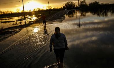
Another potent atmospheric river event has set up in northern California, once again raising the risk of dangerous flooding, landslides and damaging winds in this storm-weary region. Several additional feet of snow will also pile up in the higher terrain of the Sierra Nevada.
...
More than 5 inches of rain has fallen in the 24 hours ending 6 a.m. PST in Sonoma County at Leghorn Stream. Big Sur in Monterey County picked up more than 3 inches of rain in that time. Some western slope areas of the northern Sierra have seen 1-3 inches of rain so far.
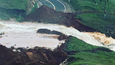
Mudslides have been reported in both Marin and Santa Cruz Counties. The Marin County mudslide closed Sir Francis Drake Boulevard near Samuel P. Taylor park due to both mud and trees on the road.
Flooding has also been reported on some roads in the Bay Area.
...
Below is a recap of the recent storms to hit the region since late last week.
February 16
The first round of this latest Pacific storm parade soaked portions of California on Thursday as a band of moisture moved southward through the Golden State.
Up to one-half inch of rain fell in much of the Bay Area. Parts of Marin and Napa Counties had picked up one-half to one inch of rain, while the wettest locations in Sonoma County had already exceeded one inch of rain. As of 4 p.m. PST Thursday, 0.37 inches of rain had fallen at San Francisco International Airport.
This first teaser rainfall event also brought rain to southern California. Much of the Santa Lucia Range received 0.20 to 0.40 inches of rain on Thursday. Lower elevations including Santa Barbara, Oxnard and Los Angeles received less than 0.05 inches.
February 17-18
A strong atmospheric river event set up in southern California, dumping heavy rainfall on Santa Barbara, Ventura and Los Angeles counties.
Multiple roads were closed in Santa Maria late Friday morning, due to flooding. Several reports of flash flooding, mudslides, urban flooding, and debris flows came in from Southern California. Nearly 9 inches of rain was dropped onto the mountains just north of Santa Barbara, while in downtown Los Angeles rainfall totals came up just short of their daily rainfall record.
The low may have also clinched the record for lowest pressure in the month of February at San Francisco Airport, a record that was last set in 1998.
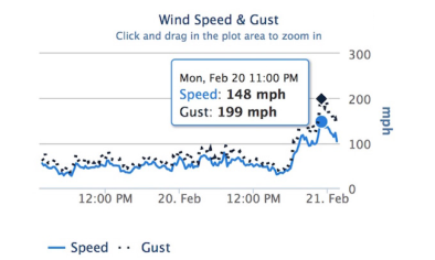
These record low pressures caused winds to ramp up during the afternoon hours.
Winds gusted across to over 50 mph across much of central and southern California, knocking over many trees and power lines. Some gusts exceeded 80 mph.
Selected Wind Gusts as on Friday [February 17], all in California:
- 108 mph was measured near Grapevine
- 84 mph was recorded in Burns Canyon
- 75 mph at Palomar Mountain Lookout
- 72 mph in Hesperia and San Clemente
- 67 mph in Laguna Beach
- 65-75 mph in San Bernardino and San Diego counties (widespread)
In San Diego and Orange Counties, a squall line developed on Friday afternoon. Strong winds pushed over numerous trees. A wind gust was reported on the Long Beach Pier.
Record daily rainfall was reported across southern California. Long Beach, Santa Barbara, Sandberg, Santa Maria and Lancaster all received more rainfall than any other February 17th. Most sites doubled or tripled their old records. Death Valley recorded record rainfall on February 18th.
Selected two-day rainfall totals in California:
Bolded values are locations where daily record rainfall occurred.
- 10.45 inches in El Deseo
- 9.95 inches at Old Man Mountain
- 9.91 inches at San Marcos Pass
- 9.87 inches at Upper Matilija Canyon
- 9.30 inches in Montecito Hills
- 7.68 inches at Red Mountain
- 7.02 inches in Los Prietos
- 6.57 inches in Westlake Village
- 6.22 inches in Opids Camp
- 5.50 inches at Crestline Ridge
- 4.84 inches at Malibu Canyon
- 4.84 inches in Canoga Park
- 4.52 inches in Oxnard
- 4.16 inches at Santa Barbara
- 3.98 inches in Rocky Butte
- 3.92 inches in Black Mountain
- 3.86 inches in Sandberg
- 2.94 inches in Laguna Hills
- 2.91 inches in Cambria
- 2.77 inches in Long Beach
- 2.74 inches in Pasadena
- 2.05 inches in Downtown Los Angeles
- 1.98 inches at Santa Maria Airport
- 1.12 inches at San Diego International Airport
- 1.05 inches in Downtown San Francisco
- 1.16 inches in Oakland
- 0.73 inches in Fresno
- 0.65 inches in Death Valley
All this rainfall in a relatively short period of time, allowed rivers and washed to fill up rapidly. The Ventura River has reported some local flooding and the Conejo Creek in Camarillo was seen water spill over into farmland.
The Pacific Coast Highway east of Santa Barbara was closed at times on Friday afternoon due to mudslides and flooding. Interstate 110 was also closed near Slauson, California on Friday evening.
The Santa Barbara Airport also closed due to flooding on runways Friday evening into Saturday morning.
Numerous swift water rescues were performed across Southern California.
In the Sierras, Ponderosa received 24 inches and Mt Baldy Ski Resort saw 20-24 inches of new snow in 48 hours ending Saturday morning and Squaw Valley received 12 inches in 24 hours ending Saturday morning. New snow at Alpine Meadows put them over 500" for the winter.
Related Content


