Super Typhoon Goni 2020
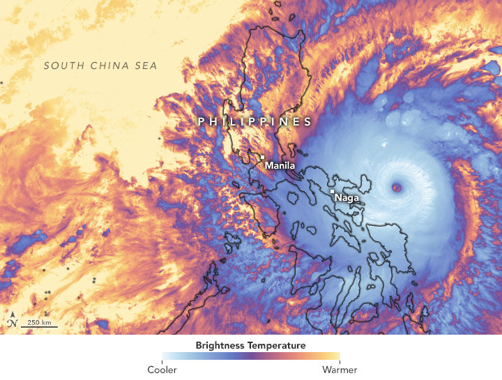
Super Typhoon Goni made landfall in the Philippines on November 1 with sustained winds of 195 mph, making it the strongest landfalling tropical cyclone on record. Climate change is increasing the likelihood of more intense and destructive storms like Goni. As the world warms, the risk of strong typhoons (also called hurricanes and tropical cyclones, depending on the basin of origin) is increasing because warmer water provide storms with more energy.
Climate science at a glance
- Typhoons get their energy by siphoning moisture and energy from warm ocean waters.
- Due to ocean warming, a greater proportion of tropical cyclones around the world are attaining major storm intensity.[1]
- With Goni, there have been four storms with 195+ mph winds since 2013, consistent with models showing climate change will increase the frequency of ultra-intense (190+ mph) category 5 tropical cyclones.
- Sea level rise enables hurricane storm surges to reach further inland and cause more flooding.
- Human-caused climate change making dangerous rapidly intensifying typhoons more common.
Climate signals breakdown
Climate signal #1: Intense Northwest Pacific typhoon frequency increase
 Warmer temperatures increase the rate of water evaporation from land and sea surfaces, which feeds moisture and energy into storms. An analysis of satellite imagery from the past four decades suggests that global warming has increased the chances of storms reaching Category 3 or higher.[1][2]
Most of the typhoons are intensifying, especially in the last quarter of the year. We are experiencing stronger typhoons than before and we can attribute it to the warming of the sea surface temperature and the warming of the atmosphere."
Esperanza Cayanan of the Office of the Deputy Administrator for Research and Development at PAGASA, the Philippines’ national meteorological agency.
Not only will there be stronger tropical cyclones, warmer air holds more water so these amplified tropical cyclones will generate heavy rainfall events, which will cause flooding and landslides over large portions of the Philippines.”
William Holden, a researcher of extreme weather in the Philippines from the University of Calgary in Alberta, Canada
Climate change is happening and affecting us, with continuous ocean warming producing stronger and more destructive tropical cyclones, like Super Typhoons Haiyan and Goni that devastated the Philippines in recent years. Bold climate actions are called for to reduce greenhouse gas emissions in order to limit the impacts and risks of climate change.”
Mei Wei, Assistant Professor at the University of North Carolina
Observations consistent with climate signal #1
- Goni’s 195 mph sustained winds at landfall made it the fifth strongest tropical cyclone on record in any basin globally, and the strongest landfalling storm on record.[3]
Climate signal #2: Increased storm surge
Climate change can lead to increases in storm surge due to rising seas, increasing storm size, and increasing storm wind speeds.[4][5] Climate change has already contributed about 6.3 inches (0.16 meters) to global sea level rise,[6] and this has dramatically amplified the impact of hurricanes by increasing baseline elevations for storm surge.[7][8]
A study analyzing the influence of climate change on Super Typhoon Haiyan's devastating 5 to 7 meter (16.4 to 23 feet) storm surge found that climate change worsened the surge by an estimated 20 percent.
Observations consistent with climate signal #2
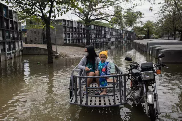
- As it made landfall, Typhoon Goni brought storm surges that were up to five meters (16.4 feet) high.
Climate signal #3: Extreme precipitation increase
One of the clearest changes in weather globally is the increasing frequency of extreme precipitation events. Warmer air can hold more moisture, which increases the amount of water available for storms to dump out as rain.[9] The fingerprint of global warming has been identified in increasing hurricane rainfall rates.[4]
Storms reach out and gather water vapor over regions that are 10-25 times as large as the precipitation area, thus multiplying the effect of increased atmospheric moisture.[9] As water vapor condenses to form clouds and rain, the conversion releases heat that adds buoyancy to the air and further fuels the storm.[10] This increases the gathering of moisture into storm clouds and further intensifies precipitation.[9]
Observations consistent with climate signal #3
- Goni brought up to 14 inches (350 millimeters) to Vietnam and an estimated 9 to 12 inches (230 to 300 mm) of rain in the regions of Metro Manila, Bicol, Calabarzon, and Central Luzon in the Philippines.
Climate signal #4: Rapid intensification
Rapid intensification is when a storm’s maximum sustained winds increase by at least 35 mph in 24 hours. Warmer ocean temperatures increase the risk of rapidly intensifying storms.
In the early 1980s, the chance of having a hurricane intensification event of 35 mph or more in a 24-hour period was about 1 in 100. Thirty years later, the chance has gone up by a factor of five to about 1 in 20.
Jim Kossin of the National Oceanic and Atmospheric Administration (NOAA)
Observations consistent with climate signal #4
- Super Typhoon Goni rapidly intensified on October 29-30, going from 95 to 175 mph in 24 hours.
Related Content
