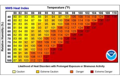
Extreme humidity: The entire eastern U.S. is a wet blanket

An extremely moist, tropical air mass has taken the entire eastern United States hostage.
From Houston to Marquette, Mich., and from Miami to Bangor, Maine, humidity is oppressively high.
This is no ordinary deep tropical air mass. Levels of atmospheric moisture streaming into the lower forty-eight from the Gulf of Mexico are among the highest ever recorded.
The superfluous atmospheric moisture pouring into the eastern United States has two primary effects: 1. It is unleashing suffocating humidity, and 2. It is fueling torrential downpours.
Dew points, which are direct measures of humidity, are unusually high over such a large area. When they exceed 70 degrees, they’re indicative of uncomfortably humid conditions. Almost every city east of the Great Plains posted dew points above 70 early Thursday.
When dew points exceed 80 degrees, the humidity is difficult to tolerate. Several locations in southeast Texas, including Houston, were reporting 80-plus dew points Thursday morning.
Dew points are forecast to remain in the 70s over large portions of the eastern United States through the weekend and even hanging on into the middle of next week along the East Coast south of New England.
When conditions are this humid, nighttime temperatures don’t cool off much. For the next several nights, record high overnight minimum temperatures are likely — particularly in the Mid-Atlantic and Northeast.
...
The plume of deep tropical moisture streaming into the eastern United States will feed thunderstorms developing near an area of low pressure in southern Mississippi and along a cold front pushing into the Midwest.
Water temperatures in both the tropical Atlantic and Gulf of Mexico are substantially warmer than normal, intensifying the heat and moisture streaming into the eastern United States
Over the next five days, widespread rainfall amounts of 3 to 6 inches are predicted along the central Gulf Coast, with localized 6 to 10 inches or more possible.
Along the central Gulf Coast, a measure of atmospheric moisture (from the surface up to the jet stream level) known as precipitable water is in the top percentile (3 to 3.5 standard deviations above normal) of historical values.
In New Orleans, the precipitable water was determined to be 2.78 inches Wednesday, which ranks among the top-five highest levels on record in August. “That is higher than some soundings [weather balloon measurements] observed here during past tropical cyclones,” the National Weather Service said.
Related Content


