Why Wildfire Relief Is Nearly Impossible This Time of Year in California

The peak time of year for California wildfires generally runs from June through October, especially across the southern half of the state. In fact, the state's 20 largest wildfires on record dating back to 1932 have all occurred during those months.
...
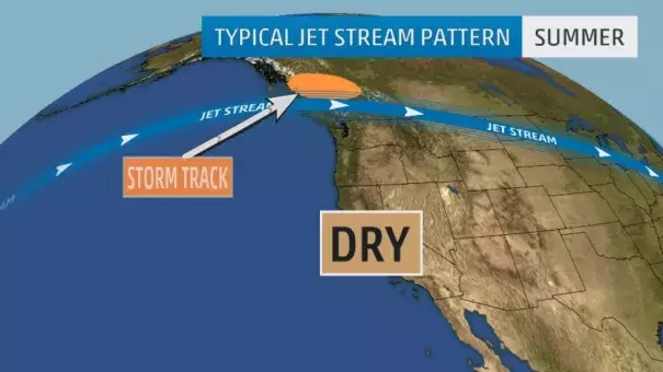
During the winter months, the jet stream often dips southward into California, allowing storms to roll in from the Pacific Ocean. In May and June, a high-pressure ridge (bulge in the jet stream) builds northward.
The result is that during the summer months, Pacific storms come in well to the north of California, and dry conditions prevail.
The ridge also produces extreme heat, especially away from the immediate coast. A pressure gradient, or a difference in air pressure, may occur between the cooler coast and hot inland areas.
...
Drought conditions have prevailed across much of California since 2012. In 2013, California recorded its driest year on record.
Lately, a ridge of high pressure aloft across the eastern Pacific has blocked storms from coming into California during the winter months. There was hope that a strong El Niño pattern during the winter of 2015-16 would produce well-above-average rainfall across California. The results were not encouraging.
Parts of northern California received near average rainfall. with a few locations recording above average precipitation, during the wet season. That wasn't the case across Southern California, where many locations only received about half their average rainfall.
For example, from November 2015 through March 2016, Los Angeles received only 5.27 inches of rain, roughly half their average rainfall – 10.26 inches – during that time. Extremely dry conditions have continued into the dry summer months of 2016, and it appears that the wildfire threat is likely to become much worse as we go deeper into the fire season
Related Content


