Explainer: What is Lake-Effect Snow?

What is Lake-Effect Snow?
Story Highlights
Lake-effect snow requires cold air passing over relatively warmer lake surfaces.
In the U.S., lake-effect snow most commonly forms downwind of the Great Lakes.
Many other lakes and bodies of water manufacture bands of snow and rain from this mechanism.
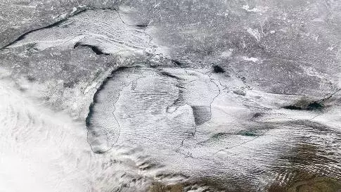
Lake-effect snow is a weather phenomenon created when cold, dry air picks up moisture and heat by passing over a relatively warmer lake, such as one of the Great Lakes or the Great Salt Lake.
The most likely time of year to get organized lake-effect snow bands is from late fall into early winter when lake temperatures are at their warmest, relative to the colder air spilling over them.
Once the lakes freeze over, the moisture and heat source is lost and lake-effect snow has a very hard time developing.
Lake-effect snow can happen in October and March, as well, though the latter is less common since lakes are at their coldest – if not frozen – and air masses are a bit warmer than earlier in winter.
One of the most memorable lake-effect snowstorms in Buffalo, New York, took place in October 2006, when 22.6 inches of snow fell in the city. Prior to this, the all-time October monthly snowfall record was only 6 inches, set in 1909.
A band of heavy lake-effect snow pummeled the Buffalo area Oct. 12-13, 2006, downing trees and power lines, and knocking out power to about a million customers in the area. Many trees still had their leaves, worsening the impacts of the snow. In fact, there was already plenty of damage reported with just the first few inches of snow that fell, the National Weather Service (NWS) in Buffalo said.
Lightning and thunder were constant during the height of the storm, according to the NWS. This was due to the very unstable environment in place with relatively mild lake waters at 61 degrees, and an air mass that was just cold enough aloft to produce the heavy snow.
Ingredients Needed for Lake-Effect Snow
While the lake, or any other sufficiently large body of water, for that matter, provides moisture to aid in the development of lake-effect snow, additional moisture is sometimes required if the wind speeds are strong.
When winds are too strong, they don't have enough time to pick up the lake's moisture for organized snow bands to form.
Upwind of the Great Lakes, northeast Canada's Hudson Bay will sometimes fuel the incoming arctic air mass with ample moisture, helping produce stronger lake-effect snowstorms.
Speaking of arctic air masses, they are another key ingredient. A general rule of thumb is that temperatures around 5,000 feet above ground must be at least 23 degrees Fahrenheit (13 degrees Celsius) colder than the lake temperature for lake-effect snow to develop.

For example, the temperature of Lake Ontario on Nov. 11, 2016, was 55 degrees Fahrenheit (13 degrees Celsius) off the coast of Rochester, New York. That means an incoming cold air mass would need to be at least 32 degrees Fahrenheit (0 degrees Celsius) or colder at 5,000 feet as it passes over Lake Ontario in order for lake-effect snow to form downwind of the lake.
If the air mass does not meet the 23-degree Fahrenheit (13-degree Celsius) threshold, the clouds will not be able to absorb enough heat and moisture from the lake for sufficient lake-effect snow to fall. At best, you'll just get some lake-effect clouds and maybe a few flurries because the air mass won't be unstable enough for significant precipitation.
Additionally, the cloud deck should be at least 5,000 feet (about a mile) above the ground to get anything more than flurries. For heavier snow, the cloud deck needs to be located at more than 7,500 feet (about 1.5 miles).
One other ingredient necessary for the formation of lake-effect snow is winds blowing in nearly the same direction throughout the lower atmosphere.
In general, the heaviest single snowbands occur when winds align roughly with the longest axis of a lake.
For example, the winds should be well-aligned out of the west, west-northwest or northwest from the surface up through about 5,000 feet for organized lake-effect snow bands downwind of Lake Ontario.
A west or southwest wind would bring the heaviest single lake bands downwind of Lake Erie.

How Lake-Effect Snow Forms
Cold, dry air crosses over a relatively warmer lake surface, which provides warmth and moisture to the air. The colder the air and the warmer the lake, the more intense the lake-effect snow bands can become.

This is why lake-effect season is typically late fall into early winter, when lake temperatures are warmer. It's easier to get that 23-degree Fahrenheit temperature difference between the lake and 5,000 feet when the lake temperature is warmer. You need a much colder air mass once the lake cools down later in the winter.
Bands of clouds, called cloud streets, form parallel to the wind. The longer the path of air over the lake, known as the fetch, the thicker the clouds grow, and then snow falls from these clouds downwind of the lake.

Each Great Lake has an optimal fetch direction, since they are orientated differently. The more optimal the fetch, the stronger the lake-effect snow band will become because the air travels over the lake for a longer duration, picking up the most heat and moisture. Here are wind directions providing the greatest fetch over each lake:
- Lake Ontario: West
- Lake Erie: Southwest
- Lake Huron: North-northwest
- Lake Michigan: North to north-northeast
- Lake Superior: Northwest, north or northeast
Interestingly, two or more Great Lakes can sometime contribute to a fetch. For example, a southwest wind could blow over Lake Erie and Lake Ontario, producing snow on the northeast ends of both lakes. Or, a northwest wind could blow over Lake Superior, Lake Huron and Lake Ontario, producing snow southeast of each of those lakes.
As mentioned earlier, once a lake freezes over, the moisture and heat source is lost and lake-effect snow has a very hard time developing downwind of that lake.
However, given Lake Ontario is the deepest of the Great Lakes, it does not completely freeze over late in the winter like the other Great Lakes can do. Therefore, lake-effect season can last all winter downwind of Lake Ontario, unlike the other Great Lakes, which may freeze over by February.
Characteristics of Lake-Effect Snow Bands
Lake-effect snow bands are much longer than they are wide. The average width of a band is about 10 miles, while the length can range from 30 to 250 miles long, depending on how strong the winds are to carry it inland.
If winds are strong, the heaviest snow falls inland. If winds are weak, the heaviest snow falls along and near the lakeshore.
According to Dr. David Kristovich, adjunct associate professor in the Department of Atmospheric Sciences at the University of Illinois in Urbana-Champaign, "There are only a handful of references that look at the monthly frequency of lake effect. Overall, these studies indicate that averaged over many years, lake-effect storms tend to occur with almost equal frequently from December to February, with a slight tendency for the peak frequency in January."

Cars with snow atop the roofs sit idle at this home on Broadway in Lancaster, New York, Wednesday, Nov. 19, 2014. (AP Photo/Gary Wiepert)
Topography downwind of the lake can enhance snowfall rates, creating very dangerous white-out conditions with hefty snow totals. This happens frequently due east of Lake Ontario on the Tug Hill Plateau.
Copenhagen, New York – located on the Tug Hill Plateau – received 12 inches of snow in one hour on Dec. 2, 1966. Montague, New York, also on the Tug Hill, picked up 40 inches of snow in just 12 hours Jan. 11-12, 1997.
The Tug Hill hamlet of Hooker, New York, holds New York's unofficial record for snowfall in a single season, with 466.9 inches during the winter of 1976-77. According to the National Weather Service in Buffalo, Hooker averages 242.2 inches of snow each season, based on 1981-2010 averages.
Larger cities that receive lake-effect snow include (1981-2010 average seasonal snowfall shown):
- Marquette, Michigan (203.6 inches)
- Syracuse, New York (124.7 inches)
- Erie, Pennsylvania (101.0 inches)
- Rochester, New York (99.3 inches)
- Buffalo, New York (92.5 inches)
- Duluth, Minnesota (81.5 inches)
- Grand Rapids, Michigan (74.8 inches)
- Cleveland, Ohio (68.3 inches)
- South Bend, Indiana (67.3 inches)
- Salt Lake City (56.0 inches)
- Milwaukee (49.3 inches)
- Chicago (37.1 inches)
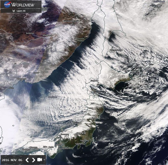
It isn't just lakes that produce snow, such as the Great Lakes or the Great Salt Lake, but ocean-effect snow is also a phenomenon.
Places like southeast Massachusetts, including Cape Cod, can receive ocean-effect snow, and it forms in the same way as lake-effect snow, except the heat and moisture source is the ocean. Ocean-effect snow (and also rain) can form off the Chesapeake Bay and, on rare occasions, parts of Florida's east coast, as well.
On the other side of the globe, heavy sea-effect snow bands develop in the fall and winter off the Sea of Japan, as seen in the MODIS satellite image below.


