A record-challenging Greenland climate pattern is boosting extreme weather in North America and Europe

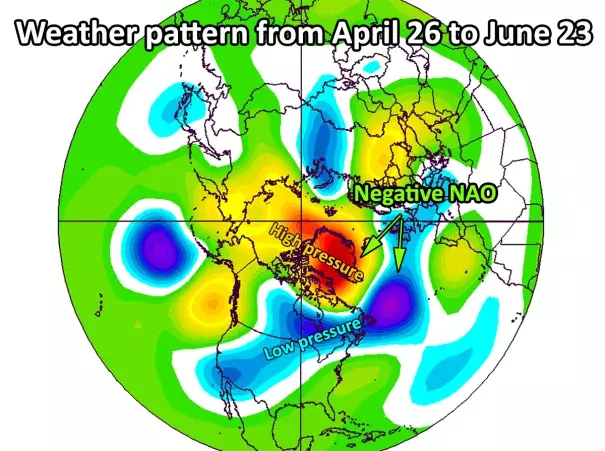
For almost two months now, a bulging zone of high pressure has stagnated near Greenland. This consequential weather pattern is poised to persist for the longest duration in modern records.
The stubborn pattern is making all kinds of weather more extreme. In May, it was connected to severe thunderstorms, tornadoes and flooding in the central United States. In June, it delivered a record-challenging early-season melt event over Greenland. This week, in concert with other weather systems, it is torching Europe in a potentially historic heat wave.
This high-pressure zone over Greenland is often referred to as a “blocking” pattern because it slows the flow of weather systems circulating around the Northern Hemisphere. When present, punishing weather extremes can affect the same areas for extended periods.
Scientists evaluate the presence of a Greenland block and its intensity and duration through an index known as the North Atlantic Oscillation (NAO). A negative NAO is often an indicator of a Greenland block, as it is now. A positive NAO signals low pressure over Greenland and generally less extreme weather over the Northern Hemisphere continents.
A negative NAO has now persisted for 61 days. Today will be day 62.

As Mika Rantanen, a meteorologist in Finland, tweeted last week, this is one of the lengthiest runs of a negative NAO on record and currently ranks third-longest. The only two longer stretches are 64 days from Dec. 22-Feb. 23 in 1963 and 68 days from June 6 to Aug. 11 in 2011.
Given that forecasts keep the negative NAO going through at least the end of the month, this run certainly has a chance to rival 2011′s record stretch. Even if doesn’t, it will be notable for being the sixth top 10 stretch since 2010 in a record back to 1950.
Related Content


