Four Storm Surges in One Storm: Perspective on Irma’s Wild Coastal Floods

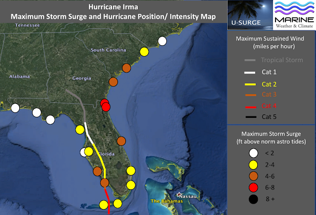
 Map of maximum storm surge data. Map created by Dr. Hal Needham (Marine Weather and Climate/ U-Surge), data provided by NOAA Tides and Currents.
As people are just returning to the worst-hit areas of the Florida Keys and southwest Florida, maximum storm surge areas are still being reported. The table below provides the mapped data in tabular form.
Storm surge observations for Hurricane Irma as of Sept. 12 at 6 a.m. ET
NOAA Tides and Currents Tide Gauges (preliminary water levels)
Fernandina Beach, Fla.:7.48 feet
Mayport, Fla.: 6.42 feet
Fort Pulaski, Ga.:5.15 feet
Naples, Fla.: 5.14 feet
Trident Pier, Fla.:4.43 feet
Fort Myers, Fla.:4.25 feet
Virginia Key, Fla.:3.91 feet
Key West, Fla.: 3.30 feet
Old Port Tampa, Fla.:3.17 feet
Vaca Key, Fla.: 2.76 feet
Charleston, S.C.: 2.55 feet
Cedar Key, Fla.: 2.50 feet
Lake Worth, Fla.: 2.23 feet
Lake Worth, Fla.: 1.96 feet
...
The highest credible storm surge observations have been reported from northeast Florida through South Carolina, including the Georgia coast. Fernandina Beach, Fla., near the Georgia border, leads the pack with a 7.48-foot storm surge observation.
Both Jacksonville and Savannah were victims of compound flooding, when prolonged onshore winds elevate storm surge levels for multiple high tide cycles and impede the drainage of heavy inland rainfalls.
...
Approximately 10-12 inches of sea-level rise in the Miami area over the past century enabled Irma to flood thousands of additional properties, even though the peak storm surge remained around 4 feet. In fact, if Irma hit one century ago, the maximum storm tide in Miami would have been around 2.88 ft, which would have ranked it 12th all-time (instead of 10th), as total water levels would have been lower than the storm tides from Hurricane Donna (1960) at 3.74 ft and Hurricane King (1950) at 3.67 ft.
Related Content


