Science Source
Tropical cyclone intensification trends during satellite era (1986–2010)
Storms are intensifying at a much more rapid pace than they used to 25 years back...They are getting stronger more quickly, and also [to a] higher category. The intensity as well as the rate of intensity is increasing.
Dev Niyogi, professor at Purdue University and study lead-author
- Finds that hurricanes and other tropical cyclones across the globe reach Category 3 wind speeds nearly nine hours earlier than they did 25 years ago
- Finds that in North America, storms have shaved almost a day (20 hours) off their spin-up to Category 3
- Uses the International Best Track Archive for Climate Stewardship (IBTrACS, version v03r03) analysis during satellite era (1986–2010) and determines the trends of intensification of tropical cyclones (TC) over all the global basins, except the North Indian Ocean
- Finds a positive rate of TC intensification over all basins from 64 kt to first peak of intensity maxima (global average value = 104 kt)
- States the above trends were significant for 4 out of 5 basins, except the North West Pacific
- Finds the trends indicate that the TCs now intensify from 64 kt to 104 kt nearly 9 hours earlier than they did 25 years back
- Finds the maximum reduction in intensification time is noticed over the North Atlantic Ocean where the average time needed for TC to intensify from 64 kt to 112 kt has reduced by nearly 20 hours during the past 25-year period
Related Content
Headline

Jun 6, 2018 | LA Times
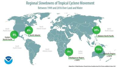
Hurricanes and typhoons are slowing down, which means more time to do damage
Headline

Jun 6, 2018 | KPRC
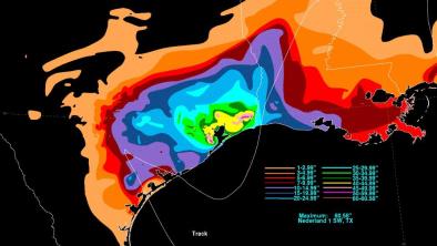
Report gives new insight into just how bad Hurricane Harvey was
Science Source
| Nature
A global slowdown of tropical-cyclone translation speed
James P. Kossin
Headline

May 24, 2018 | The Weather Channel
New NOAA Maps Show the Torrents Harvey Unleashed on Texas


