Sprawling Central U.S. Storm Takes at Least 15 Lives

A classic midlatitude spring storm churned its way across the midsection of the United States over the final weekend of April, killing at least 15 people in 5 states. The system’s threats were multifaceted: torrential rain and flooding, deadly lightning, downburst winds, and at least two strong tornadoes.
In textbook fashion, the midlatitude storm was occluding on Monday, with a cold front racing well ahead of the increasingly stacked upper- and low-level centers of low pressure over the Midwest. That cold front may still produce one more day of severe weather from the Appalachians eastward.
...
Ozarks hammered by record-high flood crests
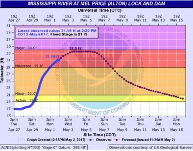
Widespread three-day rains of 5” – 10” and more pushed creeks and streams across the central U.S. out of their banks, and in many cases to unprecedented heights (see this comprehensive list from weather.com’s Jon Erdman). The disruption from closed roads and flooded structures in and near Missouri may end up on par with that produced by massive flooding not much more than a year ago, in December 2015.
Highest rainfall totals from noon CDT Friday through 3:00 am Monday included:
Houston, MO (4.5 miles ESE): 11.15”
Rogers, AR: 10.54”
Bunkie, LA: 10.00”
Savoy, OK (3 miles SE): 8.50”
Owensville, IL: 7.95”
...
Vicious tornadoes strike in East Texas
At least four people were killed, two were missing, and dozens were injured after multiple tornadoes struck parts of northeast Texas on Saturday evening. The worst was in Van Zandt County, where two weak tornadoes around 4:15 pm CDT were followed by two far more damaging twisters around 5:30 pm. The latter were both given preliminary damage ratings of EF3 after storm survey teams made their way through the wreckage on Sunday. One of those EF3s was a long-track tornado, with a path length that may have been continuous for 51 miles.
...
Ferocious late-season blizzard socks the High Plains
The central U.S. storm system dumped more than two feet of snow on the high country of southern Colorado, which isn’t all that unusual for late April. The real eye-opener was the extension of heavy snow, together with screaming winds gusting well above 40 mph, into western Kansas, the Oklahoma Panhandle, and the far northern Texas Panhandle. If the winds are blowing in this wide-open region, it doesn’t take much snow at all to produce blizzard conditions. In this case, the snowfall was more than ample.
Depth measurements are notoriously unreliable in blizzard conditions, because drifting is so widespread, but radar and satellite data support the idea that snowfall was quite substantial across far western KS. There are preliminary reports that as much as 20” fell near Colby, KS, with a corridor of foot-plus totals reported west of a line from around Garden City to Colby. Dalhart, TX, reported at least 9”. The NWS office in Dodge City called the widespread heavy amounts unprecedented for so late in the spring.
Even the modest 2.5” officially reported on Sunday at Dodge City itself marked the first time a spring snowfall has exceeded 1” in Dodge City on any calendar day after April 15. Records began at Dodge City in 1893. Interestingly, the temperature never dropped below 32°F during the entire event at Dodge City, so Sunday’s record low of 20°F was untouched, though the city did set a record-low daily maximum of 37°F.
Related Content


