Idalia Hits Florida With Dangerous Storm Surge

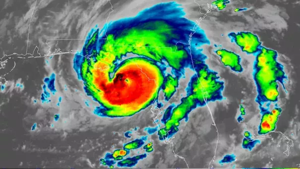
Hurricane Idalia intensified overnight into a Category 4 hurricane before making landfall as a major Category 3 storm in Florida's Big Bend region just north of Steinhatchee at 7:45 this morning, with sustained winds of 125 mph and 12 to 16-foot storm surge. The storm (pronounced ee-DAL-ya) is especially dangerous because of how quickly it intensified — a troubling pattern fueled by climate change on its way to becoming the rule more than the exception. Rapidly intensifying storms are more dangerous because they give coastal communities less time to prepare and can make evacuation more difficult or even impossible. "There’s never been as much fuel available to a hurricane as Idalia has available to it,” Climate Central meteorologist Daniel Gilfordtold the New York Times. “It’s 88, 89 degrees (31, 32 degrees Celsius) over where the storm’s going to be tracking, so that’s effectively rocket fuel for the storm,” Colorado State University hurricane researcher Phil Klotzbach told AP. “It’s basically all systems go for the storm to intensify.” Sea level rise, also fueled by climate change, is making storm surge even more dangerous — in this case, that danger is exacerbated by the added bad luck of Idalia's landfall coinciding with a Supermoon causing especially high tides.
(Landfall: Orlando Sentinel, CNN, Yahoo News; Category 4: New York Times $, AP; Rapid intensification: AP, Washington Post $, Yale Climate Connections, Politico, Bloomberg $; Storm surge: AP, Washington Post $, AP, Axios; Supermoon: AP; Cuba: AP; Coverage prior to landfall: AP, Axios, The Hill, Democracy Now, Wall Street Journal $; Ongoing Ian recovery: Politico)
(Climate Signals background: Hurricanes, Storm surge increase)
To receive climate stories like this in your inbox daily click here to sign up for the Hot News Newsletter from Climate Nexus:
Related Content


