A Giant Atmospheric River Is About to Dump Loads of Rain on California's Snowpack, Threatening Floods

California gets most of its rain during the winter, but this wet season has proven especially juicy so far. The moisture parade continued on Wednesday with a major atmospheric river descended on the Golden State, raising concerns of flooding and mudslides as it dumps heavy rain and snow across a wide region through Thursday evening.
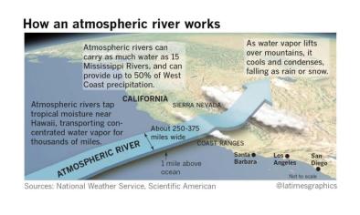
Atmospheric rivers are exactly what they sound like: long, narrow, sky-high bands of moisture originating in the tropical Pacific that speed across the ocean toward the U.S. West Coast, unleashing rain at lower elevations and snow at higher elevations. According to the National Oceanic Atmospheric Administration, big atmospheric river events can carry roughly the same amount of water as the mouth of the Mississippi.
Just a few of these events can deliver half of the West Coast’s annual rainfall, making them an important source of replenishment for ever-precarious water supplies. But when they’re as intense as the moisture plume that began to arrive this morning, they can also cause flooding, which parts of the the Bay Area are already starting to experience. As warm, moist air sweeps over snow-covered mountains further inland, it’s likely to melt snow that’s been building up at mid-elevations, triggering even worse flooding for communities in the foothills.
At the highest elevations in the Sierra Nevada, the remaining moisture will be squeezed out as snow that the National Weather Service says could total up to a whopping seven feet in some places.
Daniel Swain, a climate scientist at UCLA’s Institute of the Environment and Sustainability, said the rain California’s poised to receive “could really decimate the middle elevation snowpack” that’s been building in the inland mountains between about 3,000 and 5,000 feet of elevation. “Tonight, the big flood risk looks like it’ll come in those regions,” Swain told Earther.
Related Content


