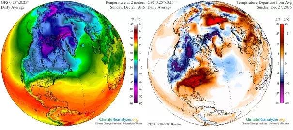
'Freak' Iceland weather bomb sets up Arctic for extreme heat

[An extreme North Atlantic] "freak" storm, powered along by an initial pulse of heat from the Gulf Stream below and powerful winds from the Jet Stream above, developed overnight into a weather bomb - a meteorological term referring to a storm whose central pressure drops by at least 24 millibars in 24 hours...Based on computer model projections, this storm is set to draw significant heat northward from the tropical Atlantic. Dragged along with the storm as it tracks past Iceland and the UK, this influx of heat is highly unusual for the Arctic in December. While these higher temperatures are not expected to reach northern regions of Canada during this brief episode, temperatures at the North Pole are expected to soar from around -30 to -35 Celsius on Tuesday, to near the freezing mark on Wednesday. Depending on how this unusual Arctic "heat wave" develops, now that the storm has passed through Iceland and is in the process of dissipating, computer models are indicating that temperatures around 15-20 degrees C above normal could circulate around the Arctic Circle into the first week of January, and there's a risk of them lingering even longer.
With the maximum Arctic sea ice extent for 2015 reaching its lowest level on record in late February, it was not a good start for the year, and the September minimum extent managed to come in as 4th lowest on record, behind 2012, 2007 and 2011. Another low start for the 2016 maximum extent, or possibly a new lowest maximum extent on record, could mean an even lower minimum - possibly even rivaling the extreme 2012 minimum - for September 2016
Related Content


