Flash Flood Devastates Ellicott City, MD

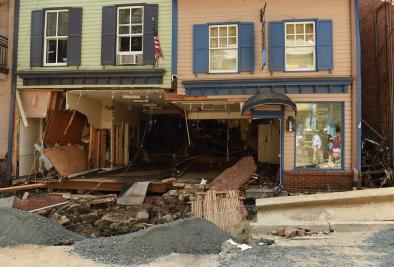
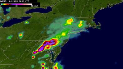
High water poured through the streets of historic Ellicott City, Maryland, on Saturday night in a dramatic flash flood (see YouTube embedded video at bottom) that killed at least two people and left a trail of damage and debris through the historic downtown area. Destruction in the city was reported to be severe, on par with the damage reported in the floods of 1868 and 1972 (the latter associated with Hurricane Agnes). While heavy rains were observed across much of the Washington/Baltimore area on Saturday evening (see Figure 7), the worst was focused near Ellicott City (Figure 8), where a rain gauge maintained by Howard County recorded the following amounts:
DURATION AMOUNT TIMEFRAME
----------------------------------------
1 minute ..0.20” - from 7:51pm-7:52pm
5 minutes ..0.80” - from 7:50pm-7:55pm
10 minutes..1.44” - from 7:50pm-8:00pm
15 minutes..2.04” - from 7:46pm-8:01pm
20 minutes..2.48” - from 7:44pm-8:04pm
30 minutes..3.16” - from 7:36pm-8:06pm
60 minutes..4.56” - from 7:30pm-8:30pm
90 minutes..5.52” - from 7:00pm-8:30pm
2 hours.....5.92” - from 6:45pm-8:45pm
Based on data from NOAA’s Atlas 14, which estimates recurrence intervals for heavy rains, the rainfall amounts within this two-hour interval have a less than one-in-a-thousand chance of occurring in any given year. Across many parts of the nation and globe, the heaviest precipitation events have become increasingly intense in recent years, with more water vapor available in an atmosphere warmed by increasing greenhouse gases paving the way for the potential for heavier rains when conditions are otherwise favorable. A Climate Central analysis shows that the Baltimore area has seen a particularly sharp increase in the heaviest downpours since the 1990s
Related Content


